What is GNSS and INS? Their Role in Precision Farming
2025-10-28
Precision farming aims to improve efficiency, cut waste, and make better use of resources in agriculture. It supports
smarter input use, higher yields, and more sustainable practices, which makes it a necessary solution in modern
agriculture.
GNSS and INS are two core technologies that make precision farming practical and effective. GNSS provides accurate
positioning data, guiding machinery along exact paths for seeding, spraying, and harvesting. INS complements this by
maintaining directional stability when satellite signals weaken or drop, such as in uneven terrain or under dense
canopy.
Together, these technologies ensure that field operations stay precise and consistent, even in challenging
conditions. In this article, CHCNAV will guide you through both GNSS and
INS one by one.
What is GNSS (Global Navigation Satellite System)? How does GNSS Work in Precision Farming?
GNSS, or Global
Navigation Satellite System, refers to a group of satellite systems that transmit signals to receivers on the
ground, allowing accurate positioning anywhere on Earth.
Some well-known systems include BeiDou (China), GPS
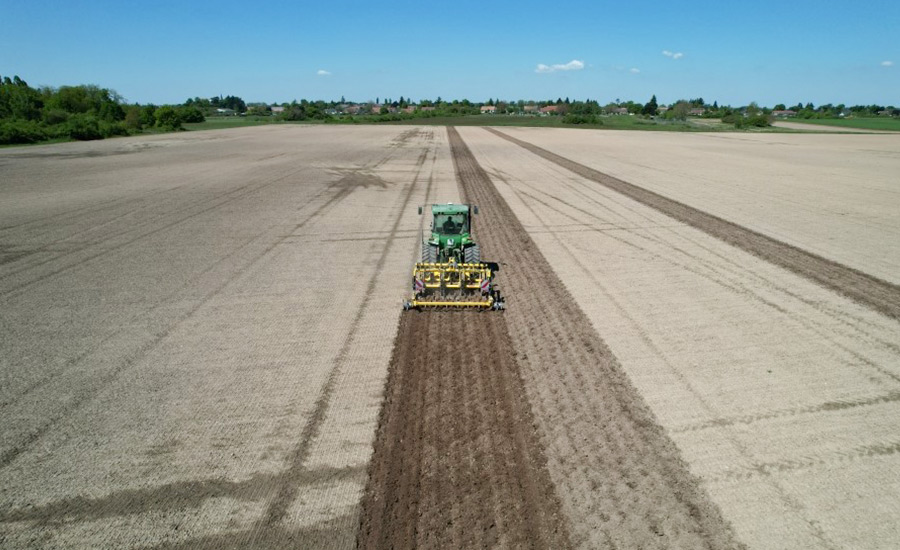
(USA), Galileo (EU), and GLONASS (Russia). In precision farming, GNSS is used to guide agricultural machinery,
such as tractors, sprayers, and harvesters, along planned routes with high accuracy.
In farming applications, GNSS receivers are mounted on agricultural equipment to track exact positions in real time.
When combined with correction signals like RTK (Real-Time Kinematics), these systems can achieve cm-level accuracy (up
to ±2.5 cm).
This level of precision enables straight and evenly spaced passes in seeding and spraying, prevents overlap, and
reduces skipped areas. As a result, farmers apply inputs more efficiently, save on fuel, and minimize soil compaction,
leading to higher productivity and improved sustainability.
What is INS (Inertial Navigation System)? How does INS Work in Precision Farming?
INS stands for Inertial Navigation System, a technology that determines movement by measuring internal changes in
acceleration and rotation without needing input from external positioning signals.
It uses accelerometers and gyroscopes to monitor a machine's position, speed, and orientation. Unlike GNSS, it does
not rely on satellite communication, which makes it especially valuable when signal quality is low or unavailable.
In precision farming, the GNSS INS integration works together to provide consistent navigation, particularly in areas
where satellite signals may be blocked, such as near tree lines, hilly terrain, or under heavy cloud cover.
When GNSS data is interrupted, INS steps in to maintain guidance accuracy by calculating movement from the last known
position. This combination ensures smoother steering, better pass-to-pass accuracy, and uninterrupted field
operations.
Significance of GNSS INS Integration
Combining GNSS and INS technologies delivers more reliable and continuous navigation than using either system alone.
Both of them have their own strengths, but together, they create a solution that is far more resilient to real-world
challenges in the field.
How INS compensates for GNSS signal interruptions
INS plays a crucial role when GNSS signals are weak, intermittent, or entirely unavailable. As tractors move through
areas with dense tree cover or poor weather conditions or operate on sloped fields, GNSS reception or positioning
accuracy may be affected.
In such moments, INS takes over, using real-time motion data from internal sensors to calculate position and
direction based on the last known GNSS reading. This ensures the machine continues on its path without drifting
off-course.
How GNSS corrects the drift and accumulated errors inherent in INS
However, INS systems alone are prone to drift over time. Small errors in sensor readings accumulate and can gradually
reduce positioning accuracy. That is where GNSS plays a vital role. Once signal reception resumes, GNSS updates the
position data and corrects deviations caused by INS drift. This feedback loop allows the integrated system to maintain
high accuracy and stability throughout the task.
Benefits of GNSS INS Integration in Agriculture
Integrating GNSS and INS technologies into farm machinery offers several tangible benefits that directly impact
productivity, sustainability, and decision-making on the ground. These benefits include:
Enhanced Precision and Efficiency
When GNSS and INS work together, agricultural operations can maintain consistent accuracy across a range of field
conditions. GNSS ensures the equipment follows exact paths, while INS keeps the system on track when satellite signals
drop.
This partnership allows tractors and implements to maintain reliable spacing and coverage without manual corrections.
It reduces steering deviations and improves alignment, which is crucial during precision-critical operations like
planting and fertilization.
Operational Cost Reduction
Improved accuracy directly translates to cost savings. By reducing overlaps and missed areas, farmers use fewer
seeds, fertilizers, and pesticides. These inputs are applied exactly where needed, lowering waste and reducing
unnecessary expenses.
This improved efficiency also means fewer passes are needed, thus reducing fuel consumption and engine hours. In
addition, automation reduces the need for manual input, which lowers the risk of operator errors.
All these contribute to less wear and tear on machinery, extending its service life and cutting long-term maintenance
expenses.
Sustainability and Environmental Impact
The precise application of inputs supports more environmentally responsible farming. Accurate spraying and
fertilizing prevent excess chemicals from entering surrounding ecosystems. Better control of machinery paths also
minimizes soil compaction, preserving soil structure and long-term field productivity.
Data-Driven Decision Making
From path deviations to equipment behavior, these systems collect high-quality data about every field operation. This
information becomes a valuable resource for farm managers, who can analyze the data, identify inefficiencies, optimize
future operations, and even predict maintenance needs. It also provides a reliable record of field activity, which is
useful for compliance, reporting, and long-term strategic planning.
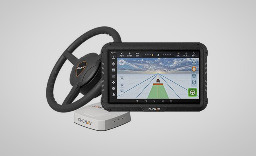
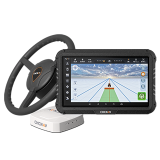
CHCNAV's High-Precision Auto-Steering Systems
CHCNAV brings advanced auto-steering solutions that integrate GNSS and INS technologies, enhancing precision and
efficiency in agricultural operations. One of the key systems in this lineup is the CHCNAV NX510 SE.
The NX510 SE is designed for easy retrofitting on various agricultural vehicles, providing up to 2.5 cm positioning
accuracy. Its GNSS+INS terrain compensation ensures consistent performance in different types of terrain.
The system comes with a 10.1-inch display with intuitive AgNav software, supporting multiple guidance patterns.
Built-in connectivity options, including 4G, UHF radio, Wi-Fi, and Bluetooth, facilitate seamless integration and
real-time data access.
Featuring versatility, the NX510 SE is compatible with a wide range of new and existing machinery, making it an ideal
choice for precision farming.
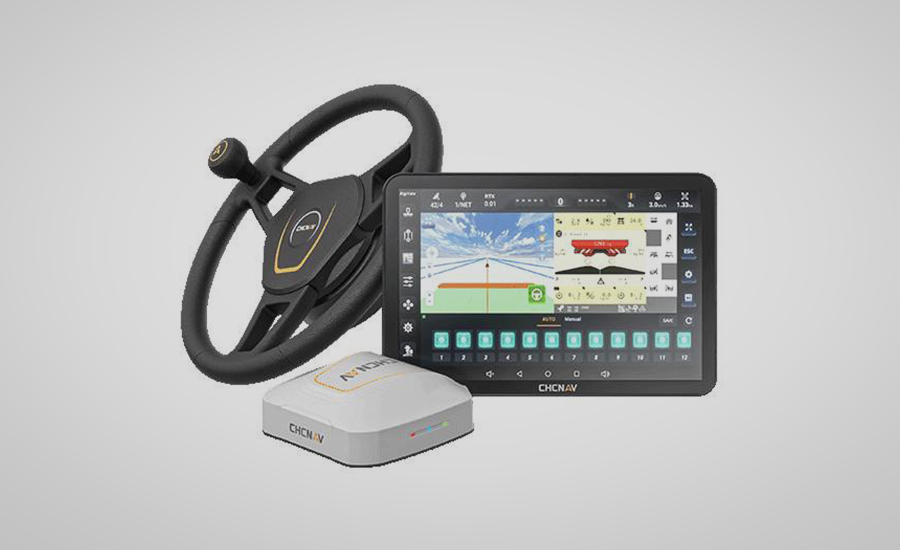
For more demanding operations, the CHCNAV NX612
delivers enhanced capabilities.
It combines multi-constellation GNSS tracking with a high-performance integrated IMU for robust positioning.
Additionally, the NX612 supports a full range of correction services and is further enhanced by CHCNAV’s PointSky
technology, maintaining ±2.5 cm accuracy even in areas with limited connectivity.
With ISOBUS compatibility, five U-turn modes, and a 12.1-inch IP67-rated touchscreen, the NX612 offers precise
implement control and user-friendly operation for a broad range of agricultural machinery.
FAQs about GNSS and INS
What is the difference between INS and GNSS?
GNSS determines position using satellite signals received from space-based constellations like GPS, Galileo, GLONASS,
and BeiDou. It offers global coverage and high positioning accuracy, especially when paired with correction services
like RTK.
On the other hand, INS calculates position, orientation, and velocity based on data from onboard sensors,
specifically accelerometers and gyroscopes. It does not depend on external signals and continues to provide navigation
data even when satellite reception is interrupted.
In agriculture, the two systems are often integrated to ensure uninterrupted and precise guidance.
What is the difference between IMU and INS?
An IMU (Inertial Measurement Unit) is a hardware component that contains accelerometers and gyroscopes. It captures
raw data about motion and rotation. An INS includes an IMU and processes its data using algorithms to estimate
position, speed, and heading. While IMU is a sensor, INS is a full navigation solution built on that sensor's input.
How accurate is inertial navigation?
Inertial navigation systems (INS) offer high short-term accuracy but suffer from drift over time due to sensor
errors, which are inherent. Position and attitude estimates degrade as small measurement errors accumulate through
integration.
High-grade INS can maintain centimeter-level accuracy with external correction (e.g., GPS), but long-term use without
external correction support may lead to significant error. Sensor quality, calibration, and environmental factors
further impact performance.
In agricultural applications, INS often works with GNSS systems to sustain accuracy. The latter provides correction
updates that keep INS errors in check, resulting in consistently accurate positioning.
Wrapping Up
Precision farming continues to evolve through the integration of advanced navigation technologies. The integration of GNSS and INS enables farmers to gain reliable and uninterrupted guidance that enhances operational accuracy, cuts resource waste, and supports long-term sustainability.
CHCNAV offers industry-leading auto-steering solutions, such as the NX510 SE and X10, which bring together these technologies in user-friendly and durable packages. Our systems are built to help farms of all sizes achieve better results with fewer inputs and less effort.
CHC Navigation (CHCNAV) develops advanced mapping, navigation and positioning solutions designed to increase productivity and efficiency. Serving industries such as geospatial, agriculture, construction and autonomy, CHCNAV delivers innovative technologies that empower professionals and drive industry advancement. With a global presence spanning over 140 countries and a team of more than 2,000 professionals, CHC Navigation is recognized as a leader in the geospatial industry and beyond. For more information about CHC Navigation [Huace:300627.SZ], please visit: www.chcnav.com