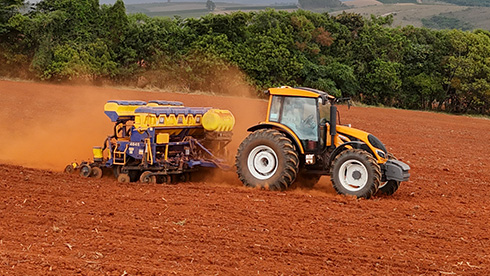
Precision agriculture has transformed farming practices, enabling modern farmers to maximize productivity, reduce waste, and manage resources more effectively. At the heart of these advancements is cutting-edge positioning technology. One of the most significant innovations is the Real-Time Kinematic (RTK) positioning system. RTK technology ensures accurate positioning and guidance, allowing for exciting farming improvements. Then, how does RTK work for precision farming, and what is RTK exactly? In this article, CHCNAV will explore this advanced positioning technology and explain its critical role in modern farming for you!
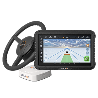
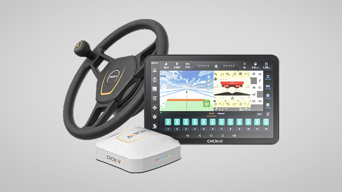
CHCNAV NX612 Autosteer Cultivating Path Control
What Is RTK Technology?
Real-time kinematic (RTK) technology is inherently a navigation correction technique for GNSS constellations, including GPS, GLONASS, Galileo, and BeiDou. The RTK technology removes signal errors caused by atmospheric conditions and other interferences.
This way, it enhances the positioning accuracy, narrowing positioning accuracy from the meter level to the centimeter level. Specifically, it can achieve a maximum positioning accuracy of 2.5 centimeters.
In the context of agriculture, this 2.5-centimeter-level accuracy enabled by GNSS RTK is significantly beneficial for various tasks such as seeding, fertilizing, and harvesting by continuously transmitting real-time corrections.
How Does GNSS RTK Work?
Then, how does RTK work? RTK technology relies on two major components: a base station and a rover (mobile receiver).
Base Station
This is a stationary station for capturing satellite signals, correcting their errors in real-time, and transmitting the corrected signal to the receiver. With the advancement of technology, several RTK modes have emerged, such as CORS RTK and satellite-based PPP-RTK. In some countries, there are free national CORS networks, which offer great convenience to users. Further, dealers also assist with RTK setup and selection during the purchasing process, helping farmers choose the most suitable solution.
Rover (Mobile Receiver)
The rover is a mobile receiver that can be mounted on different equipment, such as drones, agricultural machinery, or autonomous vehicles. It collects corrected signals from the base station via UHF/VHF radio, cellular networks (like 5G), or satellite communication. With the correction data, it adjusts its own satellite data to achieve high position and time accuracy.
Overall, here's how the process unfolds:
-
The base station measures errors in satellite signals and generates corrections.
-
Through a communication link, the base sends these corrections to the rover in real-time.
-
The rover applies the corrections for precise location data, enabling centimeter-level accuracy for agricultural tasks.
How Does RTK Work for Agriculture?
After the above discussion, you can learn that the ultimate role of GNSS RTK technology is to provide improved position and time accuracy. This important feature promotes the development of precision agriculture in the following ways:
Precision Guidance
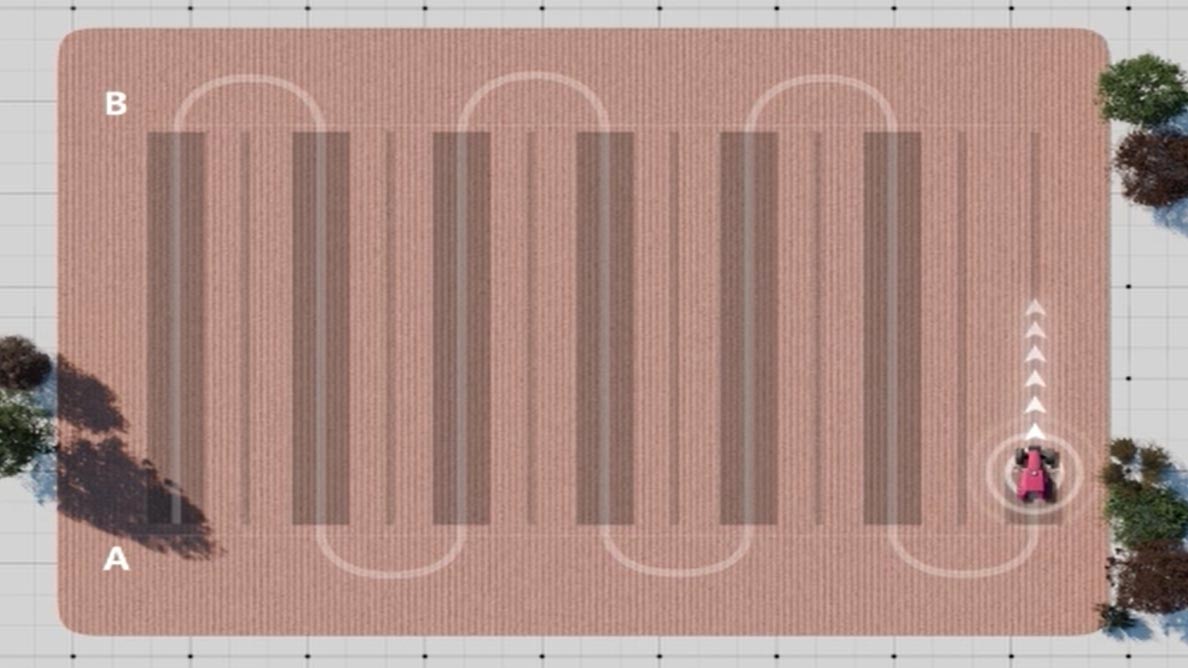
GNSS RTK is widely used for precision guidance of farming machinery. Tractors, harvesters, and other equipment can follow exact paths across fields, reducing overlaps and gaps. This ensures every centimeter of the field is utilized effectively.
Precision Guidance
Automatic Steering
With GNSS RTK, tractors can be equipped with more precise automatic steering systems. This eliminates human error, extends work hours into the night, and enables operations in poor visibility conditions such as snowy weather. This way, RTK-equipped farming machinery significantly increases overall efficiency.
Field Mapping and Management
GNSS RTK's accurate positioning capabilities aid in creating detailed field maps. These maps help farmers identify variations in soil quality, drainage, and crop yield. Such data is essential for informed decision-making.
Variable-Rate Application
GNSS RTK technology supports variable-rate applications of fertilizers, pesticides, and seeds. By applying inputs only where needed, farmers reduce waste and cut expenses while minimizing environmental impact.
Crop Planting Management
RTK plays a vital role in seeding, fertilization, and irrigation. For instance, it enables precise seeding patterns to optimize spacing and resource use. It also supports proper irrigation placement and avoids over-fertilization.
Benefits of GNSS RTK Technology in Agriculture
With its versatile applications, what benefits can you enjoy if you utilize GNSS RTK technology in your farming practices?
Increased Efficiency and Productivity
GNSS RTK ensures that agricultural machinery operates optimally, covering fields with pinpoint precision and reducing workload.
Reduced Input Costs
With precise application of seeds, fertilizers, and pesticides, farmers can significantly cut down on waste, saving money while maintaining optimal crop health.
Enhanced Crop Yield and Quality
Accurate planting and resource management result in uniform crop growth, contributing to higher yields and better-quality produce.
Improved Environmental Sustainability
By optimizing resource use, RTK minimizes environmental impact, reducing runoff of fertilizers and pesticides and preserving soil and water health.
Limitations of GNSS RTK Technology in Agriculture
While GNSS RTK provides incredible benefits, there are a few limitations to consider:
Initial Investment
Initial investment can be a significant consideration for farmers, especially for those in remote areas where there are no RTK networks, which means farmers may need to build a base station on their own. However, this investment can be recouped through increased operational efficiency and productivity in the long run. While most auto-steering solutions may come with a high price tag, they also offer substantial returns by reducing labor costs and improving yield consistency.
Network Stability Reliance
RTK corrections depend on stable communication networks. If the reference station is not available or the communication link experiences connectivity issues, the system may fail to function properly to correct the vehicle's course. Despite these challenges, GNSS RTK remains an indispensable and powerful tool for farmers looking to modernize and streamline their operations.
CHCNAV's Cutting-Edge Positioning Solutions
CHC Navigation (CHCNAV) is a global leader in precision positioning solutions, offering advanced products tailored to agriculture. Our innovative technologies make accurate positioning accessible to farmers worldwide, even in areas without RTK networks. Below are two of our prominent products for precision agriculture:
CHCNAV NX612 Automated Steering System
- High Positioning Accuracy: ±2.5 cm accuracy even in remote areas lacking network coverage.
-
Multiple GNSS & PPP Modes: RTK, SPP, DGPS, E-PPP, H-PPP, and SkyTrix.
-
Versatile Applications: Precision seeding, strip cropping, crop spraying, optimized harvesting.
CHCNAV NX612 Automated Steering System
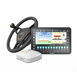
CHCNAV NX510 SE Integrated Automated Steering System for Tractors
- High-Precision Positioning: ±2.5 cm positioning accuracy by supporting multiple GNSS constellations, including GPS, GLONASS, Galileo, BeiDou, and others.
-
Wide Compatibility: Suitable for both new and old farming machinery.
-
Versatile Uses: Great for precision seeding, tillage, fertilizer application, and harvesting optimization.
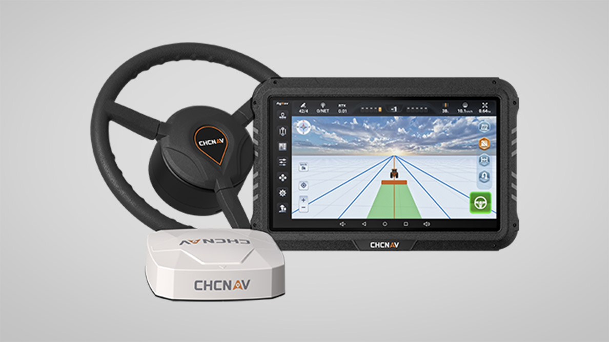
CHCNAV NX510 SE Auto Steering System
FAQs About RTK in Agriculture
Is GNSS RTK Better than Standard GNSS?
Yes, GNSS RTK is significantly better than standard GNSS. While GNSS provides positioning accuracy within a few meters, RTK enhances this to within one to two centimeters. This level of precision is critical for tasks like planting, where slight deviations can have a big impact on yield.
What Is the Difference Between RTK and GNSS?
RTK is a method of enhancing the accuracy of GNSS (Global Navigation Satellite System), which includes systems like GPS, GLONASS, Galileo, and BeiDou. GNSS provides position data, and RTK refines this data with real-time corrections.
Final Thoughts
How does GNSS RTK work for modern precision agriculture? GNSS RTK technology comes into play with the base station and mobile receivers. It enables farmers to increase efficiency, reduce costs, and enhance sustainability. While it does have limitations, the benefits far outweigh the challenges, making RTK a crucial part of modern farming practices.
For those seeking cutting-edge positioning solutions, CHCNAV offers reliable and innovative products, such as the NX612 and CHCNAV NX510 SE, that elevate precision agriculture to new heights.
For more information on CHCNAV's offerings, you are more than welcome to contact us for more details. Together, we can unlock the full potential of leading positioning techniques and propel your farming operations into the future!
____
About CHC Navigation
CHC Navigation (CHCNAV) develops advanced mapping, navigation and positioning solutions designed to increase productivity and efficiency. Serving industries such as geospatial, agriculture, construction and autonomy, CHCNAV delivers innovative technologies that empower professionals and drive industry advancement. With a global presence spanning over 140 countries and a team of more than 2,000 professionals, CHC Navigation is recognized as a leader in the geospatial industry and beyond. For more information about CHC Navigation [Huace:300627.SZ], please visit: www.chcnav.com